Let the adventure begins...
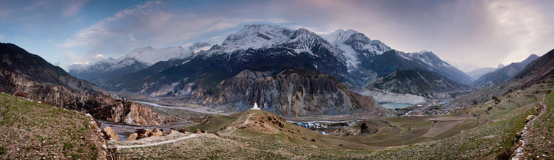
ANNAPURNA CIRCUIT TREK
There are guesthouses in all the villages scattered along the trail so set whatever pace you like and enjoy the views. The hike between Besisahar and Bhulbhule is pleasant enough. It is the jungly bit of the hike and provides a nice contrast to the various ecosystems you will be hiking through in the coming days. Therefore I would recommend against taking a bus to Bhulbhule. It will likely take you the same amount of time either way as the road is a potholed mess and the buses are slow, uncomfortable and run infrequently.
You can try and walk the lower stages at a faster pace maybe combining two of them into one so that more time can be spent on acclimatization on the higher stages. For example a couple of extra days can be spent at Manang and utilized by climbing to one of the many peaks around it and coming back down so as to increase the production of red blood cells. You can also see the origin of the Marsyandi river in Manang. Taking the high trail from Pisang via Ghyaru and Ngawal, and sleeping in either of those villages also helps acclimatization. As those villages are already higher in elevation than Manang, the extra acclimatization day in Manang can be skipped. The best part about this trek is the varied scenery it has to offer. You start from tropical forest in Besisahar, see terminal moraine near Manang and then move past the snow line across the Thorung La and then to the barren landscape of lower Mustang and Muktinath.
Besisahar (820 m) to Khudi: 7 km, 2.00 hrs
(note: It can typically be a long journey to get to Besisahar from Kathmandu. If you can arrive at a reasonable time it's worth considering walking directly on to Khudi and stopping there for the night. It'll be more basic but cheaper than the much larger Besisahar, and it will give you a good start the next morning. The first day, usually Besisahar to Bahundanda, can be brutally hot, and ends with a long climb. Knocking a couple of hours off of this and enabling you to spend more time out of the heat of the day isn't a bad thing.)
Khudi (790 m) to Bhulbhule: 2 km, 0.30 hrs
Bhulbhule (840 m) to Ngadi: 4 km, 1.15 hrs
(note: Ngadi has good views of the snow-capped mountains in the early morning)
Ngadi (890 m) to Bahundanda: 4 km, 1.45 hrs
Bahundanda (1310 m) to Ghermu: 5 km, 1.30 hrs
Ghermu (1130 m) to Jagat: 3 km, 1.30 hrs
(note: Ghermu sits in an open valley and is therefore a more pleasant place to spend the night than Jagat. Jagat is a dirty, congested village that sits in a narrow chasm.)
Jagat (1300 m) to Chamche: 4 km, 1.00 hrs
Chamche (1385 m) to Tal: 5 km, 2.30 hrs
(Tal is a nice place to stay, sitting in an open valley on a naturally dammed section of the river)
Tal (1700 m) to Karte: 4 km, 1.30 hrs
Karte (1870 m) to Dharapani: 2 km, 1.00 hrs
(note: Dharapani is a good place to stay with good views up both canyons)
Dharapani (1900 m) to Bagarchap: 2 km, 1.00 hrs
Bagarchap (2160 m) to Danaqyu: 2 km, 0.45 hrs
Danaqyu (2200 m) to Koto:
(upper trail) Danaqyu to Thanchowk: 6 km, 2.15 hrs
(upper trail) Thanchowk (2570 m) to Koto: 4 km, 1.00 hrs
(lower trail) Danaqyu to Latamarang: 1.5 km, 1.00 hrs
(lower trail) Latamarang (2400 m) to Koto: 5.5 km, 2.00 hrs
Koto (2640 m) to Chame: 2 km, 0.45 hrs
(note: Koto is small, clean and quiet as compared to the hustle and chaos of Chame. In Koto there is also a nice Tibetan Buddhist Monastery and great mountain vistas.)
Chame (2710 m) to Bhratang: 7 km, 2.00 hrs
Bhratang (2850 m) to Dhukur Pokhari: 6 km, 1.30 hrs
Dhukur Pokhari (3240 m) to Humde:
(note: there is a trail between Lower and Upper Pisang. Upper Pisang has quaint old-school lodging and an active Tibetan Buddhist Monastery worth visiting for the Sunset and Sunrise chants. Furthermore, the villages along the upper trail are full of character and the views along the trail are perhaps the best of the whole circuit, guides may try to dissuade you from doing the Upper Trail - take no notice, it is the highlight of the trek.)
(upper trail) Dhukur Pokhari to Upper Pisang: 1.5 km, 1.30 hrs
(upper trail) Upper Pisang (3310 m) to Ghyaru: 4.5 km, 1.45 hrs
(upper trail) Ghyaru (3730 m) to Ngawal: 5 km, 1.45 hrs
(upper trail) Ngawal (3680 m) to Humde: 2 km, 0.45 hrs
(Note: There are two trails leaving Ngawal - one (marked in blue and white) drops straight down to Humde, the other (marked in Red and White) stays high across a small plateau, then drops into a valley further on. The higher route is nicer but slighty longer.)
(lower trail) Dhukur Pokhari to Lower Pisang: 6 km, 1.00 hrs
(lower trail) Lower Pisang (3250 m) to Humde: 7 km, 2.00 hrs
Humde (3330 m) to Bhraga: 6 km, 1.45 hrs
Bhraga (3450 m) to Manang: 2 km, 0.30 hrs
(note: Manang is a pleasant enough place to spend a rest day. It is clean and has a couple of “movie houses” with good DVD collections. There are many day trips one can take here. A map of times, distances, and locations is next to the central stupa.)
Manang (3540 m) to Yak Kharka: 9 km, 3.00 hrs
Yak Kharka is a small collection of 3 guesthouses and lacking in other amenities, although it is preferable to Letdar which has even less in the way of accommodation.
Yak Kharka (4050 m) to Letdar: 1 km, 1.00 hrs
Letdar (4200 m) to Thorang Phedi: 5 km, 2.30 hrs
Thorang Phedi (4450 m) to High Camp: 1 km, 1.00 hrs (very steep up)
(note: High Camp has loads of beds and great views of the surrounding mountains, doing the hike to High Camp at the end of a days hiking is far more agreeable than beginning the day from Thorang Phedi at 4am bearing in mind the length of the trek to Mukinath later in the day.)
High Camp (4850 m) to Thorung Pass: 5 km, 2.15 hrs
(note: A slow hike with lots of false peaks, briefly crossing a glacial channel.)
Thorung Pass (5416 m) to Charabu: 6 km, 2.45 hrs
A steep descent, often snow and ice covered that finishes into a small collection of teahouses.
Charabu (4230 m) to Muktinath: 4 km, 1.15 hrs
(note: When you hit Muktinath, take the right hand side of the huge monastic complex in front of you to avoid a lengthy detour to the left. Mukinath is a desolate place, with few redeeming features - if you have to stay here, The Bob Marley Guesthouse in the centre of town is head and shoulders above the competition. Good food, nice showers (on the second floor) and an open fire and pool table. If possible, push on to Kagbeni which is far more charming, in a medieval Tibetan fashion.)
Muktinath (3800 m) to Kagbeni:
(note: When you arrive in Muktinath, you are back to civilization. The road starts at here and can be used to walk down. The road route is a wide, fairly level route that will get you a good distance quickly, however you will have to contend with the dust thrown up by the frequent 4x4s and less scenery. You can catch a truck from Muktinath to Jomsom for a flight, or jeep/bus all the way back to Pokhara if you want. Muktinath is also the perfect place to take a mountainbike (available for rent) and start one of the world's best downhill rides. Muktinath is not an endearing place to stay – though it is worth a brief stop at the tourist office to read up on the history and culture of the area and worth a look at the religious precint above town, holding pilgrimage sites for both Hindus (the 104 holy water spouts) and Buddhists (the eternal flames). If you have the energy after the pass you can stay down the road in Jharkot or on the other side of the valley in the very inexpensive and charming hamlets of Purang and Jhong.)
(high trail) Muktinath to Jhong: 3 km, 1.5 hrs
(high trail) Jhong (3540 m) to Kagbeni: 6 km, 1.45 hrs (Note: The high trail to Kagbeni offers fantastic views of the surrounding mountains and a taste of the upper mustang region's lovely villages (Jhong and Purang) and it's barren landscape.
(low trail) Muktinath to Jharkot: 1 km, 1 hrs (note: 1 hour is possibly longer than you would expect to take; the road is well worn and mainly on a fairly gentle downhill)
(low trail) Jharkot (3550 m) to Khinga: 3 km, 0.45 hrs
(low trail) Khinga (3355 m) to Kagbeni: 6 km, 1.45 hrs
(note: Kagbeni is an amazing little town with hidden alleyways and European like charm. It is easily a place to spend a couple of nights.)
Kagbeni (2800 m) to Eklebhatti: 2 km, 1.00 hrs
(note: The hike into gale like winds along the dusty road from Kagbeni to Jomsom with jeeps and motorbikes hurtling by at high speed is… not enjoyable. Take a jeep instead. The winds and traffic in this valley (all the way to Kalopani) get worse as the day goes on - leave early to avoid the worst of it)
Eklebhatti (2740 m) to Jomsom: 7 km, 2.00 hrs (but seems longer)
(note: hiking into Jomsom feels like hiking into a ghost town and will leave you with an uneasy feeling that you won’t find a place to stay. Keep walking. All the guesthouses are on the other side of the town by the airport. It will take about 15 minutes to get through town to where the guesthouses are. This area near the airport also has the only ATMs available on the hike. There are a number of banks, but only two with ATMs, they are unreliable and charge 400 rupees per withdrawal (with a maximum withdrawal of 10,000). There are also money changers here. From Jomsom you can either take a 15 minute flight back to Pokhara for $80 or bus it for ~$20 on a multi-stage all-day affair that will get you back to Pokhara after dark. Bus: Jomsom to Ghasa; change buses; Ghasa to Baglung (or get off at Gharkhola); change bus; Baglung to Pokhara.) )
Jomsom (2720 m) to Marpha: 6 km, 1.30 hrs (Or three hours via the new NATT trails (marked in Red and White)
Marpha (2670 m) to Tukuche: 6 km, 1.30 hrs
Tukuche (2590 m) to Kobang: 4 km, 1.00 hrs
Kobang (2640 m) to Larjung: 1 km, 1.00 hrs
Larjung (2550 m) to Kokhethanti: 3 km, 1.00 hrs
Kokhethanti (2525 m) to Kalopani/Lete: 3 km, 1.00 hrs
Kalopani/Lete (2535 m) to Ghasa: 7 km, 2.30 hrs
Ghasa (2010 m) to Kopochepani: 4 km, 1.30 hrs A route off to the left (marked with Red and White marks) takes you on a steep incline away from the road and back onto a proper path. This way is much harder, but much more fulfilling)
Kopochepani (1480 m) to Rupsechhahara: 2 km, 0.45 hrs
Rupsechhahara (1500 m) to Dana: 3 km, 1.00 hrs
Dana (1400 m) to Tatopani: 4 km, 1.30 hrs
Tatopani (1200 m) to Ghara: 5 km, 2.15 hrs
Ghara (1700 m) to Sikha: 6 km, 1.00 hrs
Sikha (1935 m) to Chitre: 1 km, 1.45 hrs
Chitre (2350 m) to Ghorepani: 2 km, 1.15 hrs
Ghorepani to Poonhill: 3km, 1.30 hrs
(note. The walk up Poon Hill in the morning can get very crowded. Rather than head up there, head up the hill on the other side (as if heading to Chomrong), you'll have a better view and you'll have it to yourself.) This alternative viewpoint has a large stone marker and a small shop selling snacks and drinks
(note. Continuing on the path mentioned in the note above, will take you along a ridge, and across a valley to the village of Chomrong, 2 days into the Annapurna Base Camp trek )
Ghorepani (2870 m) to Ulleri: 2 km, 1.00 hrs
Ulleri (2010 m) to Tikhedhunga: 2 km, 1.00 hrs
Tikhedhunga (1500 m) to Birethanti: 6 km, 2.00 hrs
Birethanti (1025 m) to Nayapul (1070 m): 1 km, 0.30 hrs Once in Naya Pul you can catch a bus or taxi back to Pokhara